
By: Margaret Sankey
The initiative of Rupert Gerritsen, Chairman of the Australia on the Map division of the Australasian Hydrographic Society, in organising this symposium to celebrate the bicentenary of the publication of Louis Freycinet’s 1811 map of New Holland underscores the too often unrecognized contribution made by the French to the early exploration of Australia.
Louis Freycinet’s map, entitled “Carte générale de la Nouvelle Hollande”, appeared in the second part of the illustrative atlas of the Baudin expedition, published in 1811.
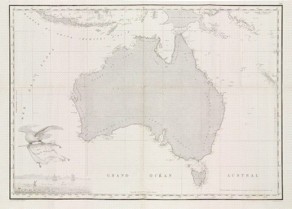
Figure 1 Louis Freycinet:Carte générale de la Nouvelle Hollande
It is arguably the first modern map of the continent that was to be christened Australia, three years later, by Matthew Flinders on his map, “A General Chart of Terra australis or Australia, showing the parts explored between 1798 and 1803 by M. Flinders, Commander of H.M.S Investigator”.

Figure 2 Matthew Flinders, “A General Chart of Terra australis or Australia, showing the parts explored between 1798 and 1803 by M. Flinders, Commander of H.M.S Investigator”
In Australian historiography, Flinders’ map has customarily been considered the first map of Australia, whereas Freycinet’s map has been either ignored or relegated to a footnote. The causes of the neglect of the map are twofold. On the one hand, the English were outraged at the prior publication of the French map with its proud representation of Terre Napoléon, particularly because Flinders had been imprisoned on the Ile de France by the French between 1804 and 1810. On the other, the French for various reasons, not the least of which was the unpopularity of the leader for the expedition, Captain Nicolas Baudin, considered that the expedition had been a failure.
Recognition of the importance of the expedition has been long in coming. In 1910, Ernest Scott in his book, Terre Napoleon: A History of French Explorations and projects in Australia, sought to reevaluate the contribution of the French to the early exploration of Australia and to refute the English claim that the French had plagiarised Flinders in the 1811 map of New Holland. It is only in recent times, however, heralded by the publication of Frank Horner’s excellent book, The French Reconnaissance in 1987, that the full scientific worth of the Baudin voyage is now being recognized and the many aspects of it explored by a growing number of scholars.
One of the main areas of endeavour of the Baudin expedition was that of hydrography. In this paper I shall situate Freycinet’s map and the Atlas of which it is a part in the more general context of the the map-making of the expedition and one of the themes that I shall develop will be the high level of interaction and cross-fertilisation that existed between the French and English in the areas of hydrography and cartography during this era. With these considerations in mind, I shall conclude my paper by discussing the English reactions to Freycinet’s map and commenting on their implications for the naming of the coastal features of the country that was to be called Australia.
The Baudin expedition to the Terres australes was commissioned by Napoleon Bonaparte, then First Consul. It was headed by Captain Nicolas Baudin in the Géographe with his second-in-command, Jacques-Félix-Emmanuel Hamelin, in the Naturaliste. The Baudin expedition was the third in a series of French scientific voyages, preceded by those of Jean-François Galaup de Lapérouse and Bruni d’Entrecasteaux. Inspired by Enlightenment ideals, the expedition was to concentrate on several fields of scientific endeavour: botany, zoology, geology and the fledgling science of man, and was to collect specimens for the Museum of Natural History. Underpinning the whole enterprise was the science of hydrography, the accurate mapping of hitherto unknown shores.
Forfait, the minister for the Navy and Colonies had instructed Claret de Fleurieu of the Institut National des Sciences et Arts to draw up instructions for Baudin concerning the itinerary of the expedition and the timetable to be followed. Particular emphasis was laid on the cartographic mission of the expedition. Fleurieu enjoined the Captain to “establish with precision the geographical position of the principal points on the coasts that he will visit, and to lay down accurate maps.” [Author’s translation.]
The expedition was to visit the Canary Islands and the Ile de France (Mauritius), before going directly to the D’Entrecasteaux Channel in Van Diemen’s land. Baudin was to look carefully for signs of English settlement there and then carry out a general reconnaissance of Bass Strait.
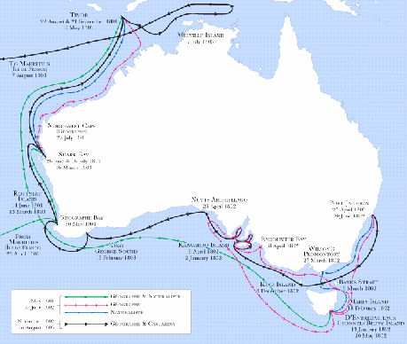
Figure 3 Track chart of Baudin expedition to New Holland
Fleurieu noted that, since the settlement of Port Jackson was relatively close-by, the English had probably already surveyed that part of the coast. Consequently, Fleurieu instructed Baudin to continue west, mapping for the first time the southern part of the New Holland coast, exploring the coastline up to the point where d’Entrecasteaux’s reconnaissance had left off.
Figure 4 Charles-François Beautemps-Beaupré, “Carte réduite de la Nouvelle Hollande et des Archipels situés au Nord et à l’Est de cette île”
Baudin was to include in his reconnaissance the islands of St Peter and St Francis.
This part of the coast has not yet been discovered. No navigator has seen it and citizen Baudin must devote himself to establishing the geographical position of the noteworthy points along, it laying down from them an accurate map which shows how it develops. [Author’s translation.]
Next, the expedition was to continue up the west coast, determining at what point the land turned easterly. Then, after spending a month and a half in Timor, the voyagers were to travel east, reconnoitering the coast of New Guinea as far as Torres Strait and to explore and visit the Gulf of Carpentaria, identified by Fleurieu as being another little known part of the coast of New Holland. Fleurieu emphasized the need to respect the timetable he had established because of the varying weather conditions at different times of the year.
The expedition left Le Havre on 27 October 1800. However, because of delay in reaching the Ile de France, and problems in obtaining supplies from the French colony, Baudin ran considerably behind with the proposed timetable and it changed radically. Instead of going directly to Van Diemen’s land and to the D’Entrecasteaux Channel the voyagers, after reaching Cape Leeuwin, went up the west coast of New Holland and then explored the north-west coastline before heading for Timor. The expedition spent two months in Timor before returning south and beginning their survey of the east coast of Tasmania.
It was because of these delays, and problems caused by several separations of the Géographe from the slower Naturaliste, that the expedition began its reconnaissance of the south coast of New Holland, approximately nine months after Fleurieu had projected. Working their way west, they met in Encounter Bay on 8 April 1802 Matthew Flinders who was travelling east. The meeting between the two captains was cordial and each acknowledged the prior discoveries of the other.
The encounter was naturally disappointing to Baudin who saw his ambition to be the first to chart more precisely the coast originally discovered and mapped by the Dutch thwarted. However, his charting of the south-eastern coast up to that point gave him confidence that, at least for some of the coast, he could claim prior discovery.
Subsequently, the Baudin expeditioners visited Port Jackson, spending several months there and purchasing an additional ship, the schooner Casuarina of which Baudin appointed Louis Freycinet captain. One of the reasons for this purchase was so that the Naturaliste could return directly to France with the specimens already collected. Another important reason was the fact that the Casuarina, having less draught, would be able to sail closer to the coast for the purposes of more accurate surveying.
Leaving Port Jackson in November 1802, the Geographe and the Casuarina proceeded down the east coast of New Holland, accompanied by the Naturaliste which left them at King Island to return to France. During this stay Louis Freycinet surveyed the Hunter Islands and Pierre-Ange Faure, one of the geographers, circumnavigated and surveyed King Island. Then the expedition sailed to Kangaroo Island where the expeditioners mapped the south coast, not previously seen by either Baudin or Flinders, and explored the interior. The expedition then sailed on to King George Sound (Albany) before rounding Cape Leeuwin and turning north, sailing east as far as Melville Island before returning to Timor. Baudin had intended to return to mapping the northern coast of New Holland but decided to sail directly to the Ile de France. It was here that, already an ill man, he would die of tuberculosis.
One of the main aims of the expedition was to map the unknown coastlines along which the ships sailed. An equally important task was the perfecting and correction of already existing maps. Baudin took this task seriously. As soon as the expedition reached the coast of New Holland, Baudin began correcting the charts with which he been provided and filling in gaps in the cartographic records. The Dutch had already mapped a large part of the coastlines of New Holland by the mid-seventeenth century.

Figure 5 The earliest map of the coasts of the continent of New Holland: Joan Blaeu’s world map, “Nova et accuratissima totius terrarum orbis tabula”,1645-8
(Wikipedia Commons)
Often, however, the measurements were approximate. Dutch and Portuguese pre-eminence in mapmaking had waned by the end of the seventeenth century. The English and French had taken over as the masters of the southern seas and were using new instruments that made more accurate surveying possible.
In the first wave of European discovery the main aim of mapmaking had been to aid navigation and indeed as primary evidence of a claim to territorial possession. By the mid eighteenth century, the general outlines of the countries of the globe had been consigned to maps, some of them approximate. The French hydrographer Charles-François Beautemps-Beaupré summed up the situation when he remarked in 1807 that
Every sea ha[s] been explored, and there remain […] no great discoveries to be made. The latitudes and longitudes of a great number of important positions [have] been determined, and these positions ha[ve] become the bases on which the corrections of marine charts [a]re to be founded.
In the second half of the eighteenth century enormous advances in the science of map-making were taking place. The English and French became active in inventing new equipment to aid navigation and in seeking to perfect their maps. As well as being scientific, these Enlightenment voyages were alive both to the possibility of trade and to the discovery of new information about the natural world. For the voyages to be effective as regards time and effort, the development of new instruments such as the sextant, octant and reflecting circle enabled more accurate surveying of the coastlines. During this period many specialized works, such as that of Beautemps-Beaupré mentioned above, were translated rapidly from one language to the other. Collaborations between English and French scientists were common, such as that between the English geographer Alexander Dalrymple and the French hydrographer Jean-Baptiste-Nicolas-Denis d’Après de Mannevillette of the East India Company, and author of the Neptune orientale, a reference used by both the French and English.
Both the French and English were interested in the South Lands and this made crucial the accurate calculation of longitude. Although the measurement of latitude had been reasonably accurate since the seventeenth century, the immense distances to be covered in the untracked ocean highlighted acutely the problem of determining longitude precisely.
Both nations strove to solve the problem, and the significant breakthrough was the development of marine chronometers. The Englishman, John Harrison, was the inventor of the clock which enabled the accurate measurement of longitude. In France the Bureau des Longitudes was established in 1795 and the watchmakers Ferdinand Berthoud and Pierre Le Roy, following closely what was happening across the Channel, also developed marine chronometers.
Beautemps-Beaupré, mentioned above, played an important role in both English and French cartography. Using the new instruments, particularly the reflecting circle, he developed methods for the more accurate charting of coastlines and for determining the position of landmarks on shore from a moving ship. Beautemps-Beaupré was a cousin and protégé of the King’s geographer Buache, then an employee of Fleurieu. Because of his outstanding skill in compiling maps in Paris from voyage data with which he was provided, he was chosen to participate in the D’Entrecasteaux voyage in 1791 in search of Lapérouse. He proved to be highly gifted at creating maps at sea.
The principal maps with which the Baudin expedition was equipped were those of Beautemps-Beaupré. His methods, taking multiple readings by means of the reflecting circle, had been inculcated in those aboard – one of his protégés, Guillaume Gicquel, was on board but left the expedition at the Ile de France because of eye problems. Most of the Beautemps-Beaupré maps were in manuscript form because the English had seized most of the French expedition’s maps in 1795 after the d’Entrecasteaux expedition had disbanded on the return journey in Surabaya. The English copied the maps, keeping them for three years before returning most, but not all, of them to the French in 1798. It is important to note here, in the context of the cross-fertilisation of English and French mapmaking, and in the light of subsequent events, that the Admiralty provided Flinders with copies of D’Entrecasteaux’s maps. The Englishman put them to good use in his exploration, acknowledging the quality of the work of the French hydrographer.
As well as the d’Entrecasteaux maps, the Baudin expedition was provided with printed world maps and more detailed maps of the various places on the itinerary, before the project arrival in New Holland. The New Holland maps included Flinders’ 1798-99 map of Bass Strait, Vancouver’s map of the Terre de Nuyts and Arrowsmith’s map of Australia, the map of New Holland published by Thévenot, and maps of St Allouarn’s voyage.
The expedition library also included various accounts of voyages, such as those of Lapérouse, Vancouver and Phillip, and comprehensive astronomic and trigonometric treatises and tables together with works on longitude.
The list of instruments provided to Baudin reveals the high hopes that were held for the success of the voyage. The expedition was given the most recent and sophisticated measuring equipment for its hydrographic surveying and map-making. The provision of the instruments was the responsibility of Lenoir who had fabricated the first reflecting circles in 1784, and Berthoud of the famous family of manufacturers of marine chronometers. As well as two sextants and four reflecting circles, there was an astronomical clock and no less than four marine chronometers, as well as numerous compasses and other equipment.
Map-making was the scientific activity on the expedition involving the largest number of specifically trained personnel. As well as the ship’s officers, the Baudin expedition had on board geographers, astronomers, engineers, hydrographers and artists who all contributed to the creation of the finished maps.
During the voyage, Captain Baudin’s journals show that he was constantly checking the accuracy of his charts and instructing his personnel to make frequent measurements. As well, he was testing the method of determining longitude using marine chronometers against the method of distances. In this process he was likewise checking the accuracy of the expedition’s chronometers.
Thus, on 5 March 1801 Baudin writes:
… we had during these four days a long sequence of observations of longitude by distances from the sun to the moon, the results of which, not in agreement with the our timekeepers, gave a difference to the east of 1o 38”. But as we had not so far experienced such a considerable one, I was not sure to what I should attribute the cause. Moreover, not having noticed anything in the daily comparison of the watches which would indicate variations, I decided my route in consequence. However, at our arrival at the Ile de France I realized that I had been wrong, since the error in their functioning was confirmed. [Author’s translation].
Two months later, on 5 May 1801, he speaks again of the discrepancy between the longitude readings given by the chronometers, and those arrived at by the distances method, indicating the problems encountered when chronometers were not accurate and the sky was covered in cloud.
During our stay at sea, the sky was not propitious for observations by distances. We could only obtain one, on 5 May 1801, the result of which gave as an average 64o6’15”. The longitude indicated by the chronometers was at the same time 64o21’57”, with the result that they took us 15 minutes 12 seconds further towards the east than the distances. [Author’s translation].
On arriving at the New Holland coast on 27 May 1801, Baudin noted that all the maps given to him by the French Navy on his departure were mistaken in their positioning of Cape Leeuwin and was at pains to correct the error.
[The maps] generally place it at 34o10’ latitude south and we were then at 34o35’58”. The longitude indicated by our timekeepers also differed from that given on the same maps, placing it at 111o25’ whereas according to our clocks, the discrepancy of which could not be significant since departure from the Ile de France, at 111o45’43”, with the result that this part of the coast seemed to us to be more to the east that it is in point of fact. [Author’s translation].
He noted likewise that Beautemps-Beaupré had thought the Cape was an island. Baudin’s journey north along the coast of Western Australia saw the discovery of Géographe Bay and the detailed mapping of Shark Bay, discovered by Dampier, as well as numerous other parts of the coastline.
As well as the duplication of the methods used in determining longitude, there was much multiplication of the record keeping of the expedition and cross-referencing was important for ensuring the accuracy of the material gathered. As well as Captain Baudin’s journal and logbooks and those of Captain Hamelin, the officers of the watch made regular entries in the ships’ logs. The officers also kept sea journals, of which there are still more than twenty known to be in existence. In addition to these records, some officers, such as Louis and Henry Freycinet, as well as recording a daily log noting the winds and weather, kept navigational journals with more detailed notation of soundings. The Captain looked over the individual journals and compared the readings of other officers with his own log. He also requested and received reports from the officers about the surveys that he had instructed them to carry out.
The captains and officers worked in close collaboration with the two geographers, Charles-Pierre Boullanger and Pierre-Ange Faure, and two astronomers, Frédérik Bissy, and Pierre-François Bernier, in the mapping of the expedition. Traditionally geographers were those who mapped the land and the hydrographers’ domain was the sea. However, in the voyage along the coastlines, in this liminal zone between the sea and the land, the roles of each category were complementary. The astronomers aided in the determination of both latitude and longitude and the geographers assisted the officers in plotting the exact position of points and landmarks, along the coast.
Bernier worked closely with the officers, carrying out the complex calculations necessary and compiling essential tables. He was also in charge of the marine chronometers which needed to be wound regularly. After he died, shortly after the second stay in Timor, the task fell to Faure and then subsequently to Boullanger, after Faure left the expedition at Mauritius on the return journey.
Under Baudin’s instructions, running survey maps of the coast were created daily during the voyage and subsequently these were translated into detailed maps with commentary. These large, sometimes coloured sheets usually consist of maps of the coastline, indicating the salient features [amers], such as capes and mountains. On many of the maps are also to be found coastal profiles, sometimes labelled by letters of the alphabet indicating the direction of particular topographical features from the ship according to the compass. The information contained on the maps was complementary to Baudin’s narrative in his journal since, as well as coastal details and soundings, they often recorded the routes followed by each ship and acted as the basis for successive route plottings of the three ships.
The map of Wilson’s Promontory below, for example, includes details of soundings of different parts of the coast, as well as the latitude and longitude of the Promontory and the path travelled by the ship. On the map appears the statement that ready reckoning has been corrected by Captain Baudin by reference to one of the marine chronometers (no 35), and that the map has been “assujettie” (or cross-referenced) to the remarks in the Captain’s journal.

Figure 6 Map of Wilson’s Promontory
(Archives nationales de France, 6JJMAR55)
The collaborative nature of the expedition’s cartography is clear from Baudin’s statement on the map that it has been drawn in accordance with to the observations of the officers, astronomer, geographer and artists, and it is clear that all the participants worked as a team under Baudin’s direction. Also on the elegantly drawn and lettered maps, but made at a later date, are rough pencil notations showing the changes made to the names given by Baudin. As we shall see, these name-changes constituted the preparation for Louis Freycinet’s map of Terre Napoléon and New Holland.
What, then, is the relationship between these maps, created during the expedition and under the supervision of Captain Baudin, and the Atlas by Louis Freycinet published seven years after the return of the expedition to France? The Captain had died on the return journey at Mauritius and the official account of the voyage had been entrusted to one of the naturalists, François Péron. It was he who wrote the first volume, entitled Voyage de découvertes aux Terres australes, published in 1807. This volume was accompanied by an Atlas of illustrations of Aborigines, native animals and plants drawn by the artists of the expedition, Charles-Alexandre Lesueur and Nicolas-Martin Petit.
Péron had intended to include in the Atlas the map of New Holland and Terre Napoléon, on which Louis Freycinet had worked in 1806 and completed in 1808, but lack of funds prevented this. Péron’s 1807 account named Terre Napoléon as being that part of the South coast of New Holland going from Port Western to the Cap des Adieux and so appeared to claim for France that part of the southern coast of New Holland which Flinders had surveyed first. Flinders at the time was still a prisoner of the French on Mauritius and thus prevented from completing and publishing his work on the circumnavigation of Australia.
Péron’s publication caused great indignation in England when the work was published in a (bad) English translation in 1809. The official British response came in the Quarterly Review of August 1810. The anonymous writer expressed his outrage, and offered the opinion that Péron had been subjected to pressure from above, suggesting sinister designs on the part of France.
The second volume of the Atlas by Louis Freycinet, published in 1811, graphically represented what had been perceived by the English as a blatant land grab on the part of the French. Unlike the first part of the Atlas published in 1807, which contained mainly illustrations of the animals and indigenous people encountered during the voyage, this Atlas consisted entirely of maps.
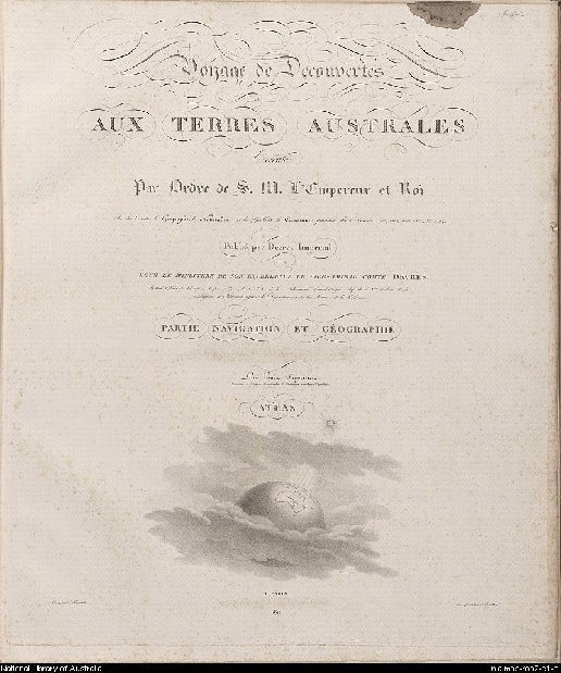
Figure 7 Title page of the 1812 Atlas of the Voyage de découvertes
On the title page Freycinet describes himself as Capitaine de frégate commanding the schooner Casuarina during the Expedition. The commander of the expedition, Captain Nicolas Baudin, is not mentioned. Below the title of the volume and the reference to Napoleon as having commissioned the expedition, the words “Et folget ipse” continues the the homage to Napoleon and can be translated as “New Holland is also lit by one of his rays.” These words appear in the outline of New Holland on the world globe, illuminated by a star.
The first map in the Atlas, the “Carte générale de la Nouvelle Hollande et des îles qui l’avoisinent”, mentioned above, traces the outline of New Holland, clearly representing the Terre Napoléon. The map is presented as a showpiece of French cartography and its title is framed in a decorative manner by the artist Lesueur. The title of the map is written on a banner draped over Neptune’s trident, carried by a menacing looking imperial eagle, gazing covetously towards the Terre Napoléon. Below are depicted the three ships of the expedition, together with fish and waterbirds.
The Terre Napoléon is the heart and focus of the Atlas. Nine of the thirty-two maps in the volume are devoted to its representation and the many place names on the map celebrate contemporary personalities of Napoléon’s time. The first map in this series has another ornate cartouche by Lesueur framing the title “Carte Générale de la Terre Napoléon (à la Nouvelle Hollande)”.
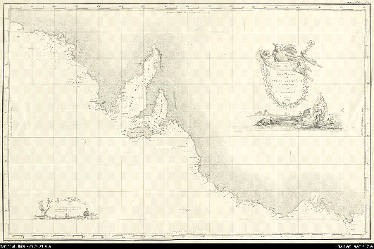
Figure 8 Louis Freycinet, Terre Napoléon map, from the Atlas of the Voyage de Découvertes, 1812.
On the right-hand side, above the title, a winged Mercury holds a banner in which Freycinet’s name is framed by native leaves and flowers. The words on the banner, “Orbis Australis dulces exuviae”, can be translated as “Australia’s Sweet Spoils.” Below the banner is a beautifully drawn scene of reclining kangaroos and, further off, seals disporting themselves on an island. On the left hand side is a subsidiary Edenic scene in which emus, grass-trees, another native tree and some native birds, including a parrot, frame the expedition ships. This cartouche contains comments on the soundings made. Another map is that of the Hunter Islands in the Bass Strait, the reconnaissance of which was the first carried out by Freycinet in the Casuarina.
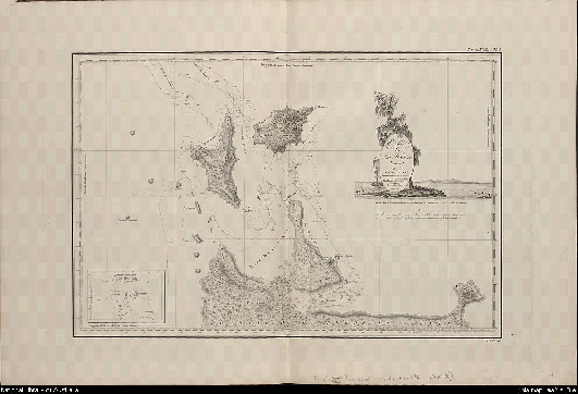
Figure 9 Louis Freycinet, “Hunter Islands, Bass Strait”, Atlas, Voyage de découvertes
This map also has a decorative frame for its title. A casuarina tree with the schooner Casuarina appears against the backdrop of the profile of Cap Berthoud. On his map Freycinet included Flinders’ map of 1798 of the islands in order to demonstrate the comparative thoroughness of his own.
On all of the maps except three, Freycinet names himself as having been responsible for drawing (dresser) the map. Also on each map are indicated the names of those who completed the survey (lever) on which the map is based – usually either of the geographers, Faure or Boullanger, but sometimes Louis Freycinet himself. In some cases the word “rédigé” (“edited”) is used. This refers to the cases where the map is a redrawing of one originally created by others, such as when Freycinet includes maps made by other explorers to compare with his own.
As well as the nine Terre Napoléon (including Kangaroo Island) maps, the volume contains five of Van Diemen’s Land, three of Bass Strait and King Island, ten of the south, west and north coasts of what is now Western Australia, as well as a plan of the English town of Port Jackson and another of the Cumberland plain. The volume ends with two maps of Timor and Asia. Several maps in the Atlas are named as being composites of surveys of two different periods when the coast was visited. The French Atlas as a whole is a work of meticulously carried out hydrography and corrects errors from previous maps as it fills in many gaps in the Australian coastline.
Presenting an idyllic, exotic and enticing picture of New Holland, Louis Freycinet’s Atlas can be seen as a monument to the officer’s cartographic skills. There is no doubt that Freycinet claims ownership of the Atlas and places his stamp on it in significant ways. Freycinet was, however, anxious to give credit where it was due. In the volume Navigation et géographie, intended to accompany the Atlas but not published until 1815, Freycinet acknowledges his debt to his collaborators and details the considerable work undertaken by himself and his team of geographers to ensure the accuracy of the measurements and calculations.
MM Bernier, Boullanger, Faure, Hamelin, Henry Freycinet and I were particularly occupied with observations of the hourly angles. As far as the lunar distances were concerned, this way of obtaining longitude was familiar to all the expedition officers, and several were involved in this. However the results found by this method having to be subjected to significant corrections to free them from the errors in the lunar tables, we had to choose the journals which lent themselves best to this kind of work. [Author’s translation].
Louis Freycinet considered that journals of his brother, Henry, and those of Bernier were the most useful in this respect. He also pays tribute to Boullanger for his careful and painstaking calculation of longitudes, obtained by using the lunar tables, and then cross-checking the results with those obtained using the chronometers.
Freycinet also refers to his own cross-checking of details recorded in the journals of the expedition as a basis for his compilation of the maps and mentions specifically the “geographical details” contained in the journals of Baudin and others.
The journals of Commander Baudin, those of MM. Hamelin, Péron, Bailly, Boullanger, Leschenault, H. Freycinet, Faure, Ronsard, Ransonnet, Montbazin and Breton have been particularly useful to me for the geographical descriptions. [Author’s translation].
It is curious in this context that he does not acknowledge Baudin’s running survey maps, mentioned above. As we have said, there would originally have been more than one hundred of these and those to which we have access are palimpsests, containing information about successive stages in the mapmaking process which culminated in Louis Freycinet’s Atlas. Most of these maps have been handled and used by Freycinet and others, such as Boullanger, because they contain later pencil notations in Louis’ distinctive hand and sometimes (mainly red) ink notations in other hands. It is clear, because of the nature of the maps, and the use that has been made of them, that they constituted a valuable and unacknowledged resource for Louis Freycinet’s mapmaking.
Olivier Chapuis has spoken of a “war of names” in evoking the controversy concerning the attribution of French names in the Atlas to the parts of the Terre Napoléon discovered first by the English. Underlying this use of conflict is another, more insidious usurpation concerning the names that Baudin, with his prerogative as captain, had given to coastal features. I have referred above to Freycinet’s pencil notations on Baudin’s original maps. These consist largely of the crossing out of the names attributed to coastal features by Baudin and their replacement with names chosen by Freycinet and others. It is these new names that appear on Freycinet’s maps and largest concentration of these is to be found on the coastal features of the Terre Napoléon. The new names, given by Freycinet and others, are focused on honouring Napoleon and his imperial régime whereas the names attributed by Baudin generally refer to the topographic features of the coastline. In this context, and given the use that Freycinet made of Baudin’s maps, it is perhaps not surprising that the latter did not want to draw any more attention to Baudin’s maps than was necessary. It is, however, regrettable that Baudin is not given the credit demonstrably due to him in the cartographic work of the expedition.
Matthew Flinders was outraged at the publication of the 1811 Atlas, on the basis of the accepted convention that naming is tantamount to claiming. Freycinet explained in 1815 why he had retained the Terre Napoléon denomination in the Atlas of 1811:
The first volume of the history of our voyage, written by Péron, caused Mr Flinders to attack our nomenclature, and to claim the right of first discovery, relative to the parts of the South East coast of New Holland, seen, in the first instance by him and by Captain Grant.
While agreeing that these navigators have priority of discovery for the lands that they saw before we did, which neither Mr. Peron and I have never denied, it is true to say that we were not acquainted with the material from their voyages until our return to France and since they have been made public. Our exploration is therefore also a work of discovery; and as far as the nomenclature of the English is concerned, it is obvious that we could not use it before we knew it. [Author’s translation].
Flinders’ map with his own nomenclature was published in 1814 and in the second French edition of the Voyage de découvertes that Louis Freycinet published in 1824 the name Terre Napoléon had been expunged and the French names given by the Baudin expedition replaced by Flinders’ names. Flinders was, however, careful on his map to acknowledge places where Baudin’s discoveries had been prior to his own.
The flurry over the Terre Napoléon and the backdown of the French had other consequences for the naming of places on the Australian continent. Priority of discovery and naming go hand in hand but in this case, because the French had been placed at a disadvantage due to the Terre Napoléon débâcle, a number of sites first named by the French during both the Baudin and the D’Entrecasteaux expeditions, subsequently received English names. Some of these, because of the efforts of a great-nephew of Fleurieu visiting Australia in 1911, had their names changed back to the original French names. Nevertheless, a significant number of places named initially by the French, particularly the names attributed by Beautemps-Beaupré during the D’Entrecasteaux expedition in Tasmania, have kept the English names which had replaced the French.
In my paper I have attempted to show the closely intertwined relations between English and French mapmaking and the extent to which the two nations were working together and building on each other’s expertise: Baudin was using Arrowsmith’s and Flinders’ published maps, just as Flinders was using Beautemps-Beaupré’s maps, and each nation was sharing the nautical expertise of the other in their joint quest for accuracy in mapmaking. At the same time also, as rivals and traditional enemies, the English and French were engaged as we have seen, in games of one-upmanship, bluffing and downright double-dealing.
Freycinet’s and Flinders’ maps of Australia were complementary in many respects in their detail of the Australian coastline and each represented the hydrographic expertise of its creator. In terms of the dynamics involved in claims for priority of discovery it was indeed unfortunate that Flinders imprisonment by the French on Mauritius delayed the publication of his map until 1814. Flinders work, as we have mentioned, owed much to the prior mapping of the French cartographer Beautemps-Beaupré, particularly as regards the east coast of Van Diemen’s land. For the creation of his 1814 map of New Holland he was likewise able to take advantage of the prior publication of the maps of the Baudin expedition, against which he could check his own.
The subsequent history of Australia, however, has been told from the English perspective, which has tended to write the French out of the story. It is time now for us to be more even-handed in our attributions and recognise the role in the cartography of Australia played by the French explorers. In particular, we should officially acknowledge that Louis Freycinet created the first modern map of New Holland, although it was of course Flinders who christened the continent Australia.