
Jean Fornasiero and John West-Sooby
Every picture tells a story, and this is no less true of maps and charts than it is of other types of images. As pictorial representations, maps and charts are in fact particularly strong sources of narrative since their common functions include reproducing the itinerary of a journey or illustrating acts of naming and possession, as well as defining boundaries. In this regard, the maps of the great voyages of discovery have particularly engrossing stories to tell, covering as they do every narrative range, from the grotesque to the sublime. The Baudin expedition to Australia in 1800-1804, is no different. Indeed, its maps reflect more than their fair share of drama – including tales of death, friendship, betrayal and revenge, all of which are forever reflected in the names they bear and the features they highlight. However, the stories that feed into the maps and their features, stories which are largely known and decipherable, are not the only narratives that emerge. The construction of maps is also determined by the authorities who commission them, the experts who choose them and the hands that draw them. And it is this particular narrative dimension that interests us here, for it represents a series of choices about what the narrator or narrators consider appropriate to relate and how they wish their narrative to be perceived. In the case of a voyage of discovery, the production of maps is closely related to the establishment of control over the expedition’s results and reputation. With its history of contested authority and following the death of its leader, the Baudin expedition was in great need of a dominant narrative to restore its integrity once it had completed its journey. In 1805, the year following the expedition’s return, the Minister of Marine thus determined that the expedition’s maps could fulfil this function and entrusted the task to Louis Freycinet.
The interest of the State in the narrative to be told by the maps was clear, but the authorities required more convincing to publish the story of the expedition itself. And perhaps they had had good reason to hesitate. The publication of the first volume of the historical account of the voyage, in 1807, did not in fact provide quite the exemplary tale intended. In it, François Péron did succeed in highlighting the scientific achievements of the expedition; at the same time, however, by demonising his commander, he constructed a dramatic structure in which great achievements were almost overshadowed by images of cruelty, incompetence and poor management. Moreover, in claiming naming rights over the vast stretch of Australia’s southern coastline that had been jointly discovered by James Grant, Matthew Flinders and Nicolas Baudin, with important contributions also from Francis Barrallier and John Murray, Péron had courted further controversy, this time with the English. Even though Freycinet himself, as designated cartographer, could not be dissociated from this particular controversy, he clearly had a lot of ground to make up when, after Péron’s death in 1810, he proceeded with the publication of the atlas of maps and of the hydrographic results of the expedition, in addition to completing Péron’s historical account. How then was he to cast his narrative?
The nature of his mapping project is, of course, revealed in the maps and charts that were published in 1811, in the first edition of the Atlas of the Baudin expedition; but his aims and intentions are also apparent in the second Atlas, devoted entirely to cartography and dated 1812 (though only published in 1814), and in its companion volume, compiled by Freycinet and entitled Navigation et géographie. It is indeed in this latter volume, published in 1815, that Freycinet reveals overtly the extent to which he has taken over the moral leadership of the expedition, even though the signs of his determination to adopt a position of authority and responsibility can already be detected in the features of the maps and charts published in 1811. As he himself notes in the Preface to Navigation et géographie: “On our return to France, we saw with astonishment that there was a prevailing prejudice against our work that was so unfavourable that this work was already considered as being unworthy of publication”. It is in this context that we need to consider the cartography of the “Voyage of Discovery to the Southern Lands”. For Louis Freycinet in particular, the publication enterprise could only serve as an act of redemption and rehabilitation. The various maps, plans and sketches, in addition to the enrichment of geographical knowledge that they embodied and to the technical and aesthetic qualities they displayed, provided an illustrated story of the voyage’s achievements that complemented the tale told in the official account. By bringing these maps to the attention of the authorities and of the public at large, he intended to re-position the expedition as the noble undertaking it was deemed at the very outset to be and to reclaim some dignity and pride both for himself and for the collective group of his fellow expeditioners – and consequently for the nation itself.
In order to measure these intentions and motivations against his achievements, our focus will be on the “narrative” that can be read into the range of features that are included on these maps – the textual and the iconographic, in addition to the more strictly hydrographic details. Rather than re-assess the technical achievements of Louis Freycinet as a cartographer, a task which others, such as Geoffrey Ingleton, have expertly accomplished, we have subjected a sample of Freycinet’s maps to an analysis on the three levels that correspond to the pressures to which he, as cartographer, was subjected and by which he was motivated: the national, the collective, the personal. Naturally, given the dilemma posed by the overtly nationalistic nomenclature imposed on the “unknown south coast” of Australia – a gesture which was at odds with a long tradition of cooperation between British and French cartographers – we are led to commence with “Terre Napoléon”, and with the controversial figure at the heart of it.
There were many reasons why Napoleon Bonaparte, as First Consul, decided to approve this voyage of discovery to the southern lands, but, notwithstanding the potential it offered for gaining commercial or geo-political advantage over the English, high on the list was certainly the prestige that would be derived for the nation from the scientific discoveries it promised to make. In drawing up his maps, Freycinet was acutely aware of the significant contribution this expedition stood to make to the sense of national pride. The map of “Terre Napoléon” provides a perfect illustration of this.
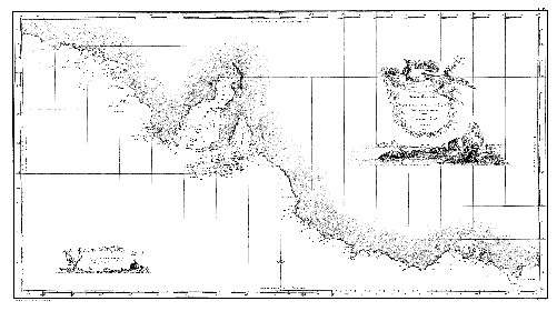
Figure 1 Carte Générale de la Terre Napoléon, L. Freycinet (1808)
Published in the Atlas of the Voyage de découvertes aux Terres Australes (1811)
After all, the charting of the previously unknown south coast of New Holland was one of the main geographic objectives established for the expedition by Fleurieu. It was also no coincidence that it was one of the prime goals assigned to Matthew Flinders, who arrived in Australian waters some six months after the French. In the end, the fateful meeting between Flinders and Baudin in Encounter Bay would reveal that the Englishman had managed to survey the greater part of that coastline. And the subsequent revelation of James Grant’s survey of much of what is now the Victorian coastline, as incomplete as it may have been, further diminished the actual discovery of the French to the rather featureless and, to their eyes, arid and monotonous section of coastline corresponding more or less to what is known today as the Coorong. The “unknown south coast” was thus a sore point in terms of national pride for both the English and the French, but much more so for Baudin and his men.
It is in this context that we need to consider the names that feature on Freycinet’s map of “Terre Napoléon”, for the story they tell is one of an attempt to reassert national pride. What these names point to first and foremost is the silence they impose on the commander of the expedition, Nicolas Baudin. During the course of his reconnaissance, Baudin conferred many names on features of this stretch of coastline, all of which figure on the sketches and draft maps that were compiled along the way, and some of which he also mentions in his sea-log. But nearly all of them were changed by Freycinet, in collaboration with François Péron, for reasons that relate to the issue of national honour as much as to their desire to expunge Baudin from the record. The names that Baudin conferred on the two South Australian gulfs, for example, were clearly deemed unworthy of such prominent geographical features and were perhaps even seen as casting derision on the expedition’s achievements in surveying them. His “Golfe de la Misanthropie” and “Golfe de la Mélomanie” thus became, respectively, “Golfe Joséphine” and “Golfe Bonaparte”.
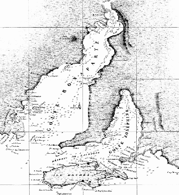
Figure 2 Detail of Louis Freycinet’s map of Terre Napoléon
showing the two gulfs of present-day South Australia
Freycinet would have drawn additional motivation for changing these names from the fact that it was he who had conducted the detailed survey of the two gulfs in the Casuarina, and that he had felt abandoned by Baudin, with precious little water and supplies remaining, as he returned from that survey. Freycinet had also conducted the close in-shore survey of Kangaroo Island and, in his narrative account of the expedition’s geographic work, Navigation et géographie, he further points out that the reconnaissance of Terre Napoléon “required two painful and difficult campaigns”. Freycinet would consequently have felt a sense of ownership over the main features of this map and would have considered himself more than justified in assuming greater rights to naming here than his commander.
Logically enough, the names of various members of the Bonaparte dynasty feature prominently on Freycinet’s map of Terre Napoléon (the Emperor and Empress, of course, along with Caroline, Pauline, Louis). Homage is also paid to a number of Napoleon’s military triumphs (Rivoli, Mondovi etc.). In contrast, Baudin’s nomenclature was much more sparing in terms of his commemoration of the current political regime. His predilection was for figures of naval history or, in keeping with his interest in natural history, animals (Camel Island, Dolphin Point, for example). Freycinet was very much the naval officer, of course, and the community of mariners is given due recognition in his nomenclature; but even such an iconic figure as Borda, the great navigator and mathematician, was denied the acknowledgment Baudin had granted him when Freycinet re-named Baudin’s Borda Island and Flinders’ Kangaroo Island in order to honour the serving Minister of Marine, Denis Decrès. In rejecting Baudin’s nomenclature and imposing names that celebrated the nation as it was at the time, Freycinet was reinstating national pride within the political context of the regime that had sponsored the expedition and sent it forth. In the process, he may well have been currying favour, but he was also making a bold statement. Through his nomenclature, Freycinet was saying: this is who we are now – a powerful nation.
This spirit is evident in the cartouches that adorn the map of Terre Napoléon. In the larger of the two, the figure of Mercury or Hermes is depicted carrying a banner bearing an inscription in Latin.
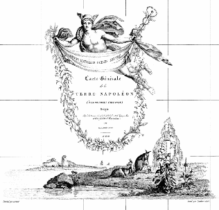
Figure 3 Detail of Louis Freycinet’s map of Terre Napoléon showing the larger of the two cartouches
The classical reference is further emphasised by the wreath that hangs from the banner, though in a rather nice variation this appears to be made up of native Australian plants and flowers instead of the usual laurel leaves. The Latin inscription signals the sweet fruits or spoils of the Austral land – an acknowledgment of the rich harvest of flora and fauna specimens that the Baudin expedition found there, and that are also represented in the vignette. The choice of Mercury is significant: he was of course the messenger, but also the god of travellers and of trade – a clear reference to the expeditioners themselves and to the commercial opportunities their discoveries might open up for France. The overall impression conveyed by this cartouche is thus one of grandeur and nobility, and the classical references are also in harmony with the preoccupation in Republican and Imperial France with Ancient Rome.
A sense of maritime history is likewise conveyed by the cartouches on the map of “Terre Napoléon”, both of which provide Freycinet with an opportunity to remind us that this map is the result of a voyage of exploration and discovery, and as such highlights France’s role in the grand Enlightenment project of knowing the world, its peoples and its natural history. Both of the vignettes to be found on the map of Terre Napoléon depict two ships: the Géographe is undoubtedly depicted in both, and the other ship in the larger of the two cartouches is most likely the Naturaliste, which was responsible for the detailed survey of Western Port and Wilson’s Promontory; in the smaller cartouche, the second vessel is almost certainly the Casuarina, which Louis Freycinet himself commanded and in which he surveyed Kangaroo Island and South Australia’s two gulfs.
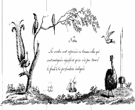
Figure 4 Detail of Louis Freycinet’s map of Terre Napoléon
showing the smaller of the two cartouches
The narrative of the scientific work conducted by the expedition is equally inscribed within these same cartouches. The kangaroo family and the plants in the main cartouche, for example, clearly identify the voyage as one engaged in natural history, and situate its work in the uniquely Australian context. The elephant seals in the background are a discreet nod to François Péron’s observations on these animals during his time on King Island, and which he presents in some detail in his official account of the voyage. The smaller cartouche on that same map also features uniquely Australian flora and fauna, with a focus here on bird life: the lyre bird is clearly identifiable, as is the cockatoo, while the emu next to the grass tree could well be one of the famous dwarf emus from King Island or Kangaroo Island. In each element of the cartouches, the theme of discovery, linked to emblems of imperial France, reinforces the message of national pride.
Freycinet was not only concerned with the issue of national pride, however; he was also keen to reclaim some dignity and recognition for the collective group of officers and scientists who had participated in the expedition, and whose honour had been impugned by the rumours regarding the failure of their campaign. As a senior naval officer, Freycinet understood that the process of rehabilitating the reputation of the expeditioners needed to start with the establishment of the significance of their results in the domain that represented the heart and soul of maritime exploration: navigation and geography. The hydrographic work conducted in the south-east of Tasmania offered him the ideal opportunity to stake a claim for the value and importance of the cartographic achievements of the collective group.
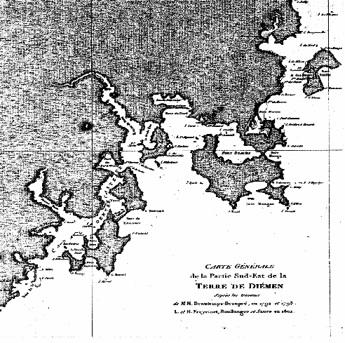
Figure 5Carte Générale de la Partie Sud-Est de la Terre de Diémen,
L. & H. Freycinet, Boullanger & Faure (1802)
Published in the Atlas of the Voyage de découvertes aux Terres Australes (1811)
In order to chart the intricate and complex nature of the coastline in this part of Van Diemen’s Land, all of the resources of the specially trained officers and geographers needed to be deployed. The task was indeed immensely challenging. But in undertaking this work, they were conscious that they were following in the footsteps of a number of illustrious predecessors and that they would be building on the collective work of earlier visitors to the region, in particular their compatriots Marc Joseph Marion-Dufresne and Antoine Bruni d’Entrecasteaux. Evidence that they were acutely aware of this heritage can be found in the journals kept by the various expeditioners, as well as in the official account, where regular and appreciative reference is made to the charts of south-east Tasmania compiled by d’Entrecasteaux’s hydrographer, Charles François Beautemps-Beaupré. The officers and scientists on board the Baudin expedition therefore knew that they not only formed their own particular club, but that they also belonged to a larger group of distinguished mariners who had visited this area. It is no surprise, then, to find that Baudin and his men felt quite at home here, as the lyrical descriptions of south-east Tasmania to be found in Péron’s narrative suggest.
This sense of self-awareness regarding their place in the history of national and international maritime exploration is clearly conveyed in Freycinet’s more detailed map of south-east Tasmania through the inclusion of what he calls a “comparative tableau” – a feature to be found on a number of the maps in his Navigation et géographie atlas.
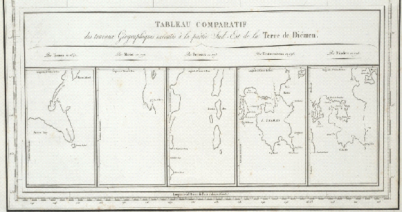
Figure 6 Detail of Louis Freycinet’s Carte particulière de la côte sud-est de la Terre de Diémen (février 1802) showing the comparative tableaux
Published in the Atlas accompanying Louis Freycinet’s Navigation et géographie volume of the Voyage de découvertes aux Terres Australes (1812 [1814])
In every case, these tableaux show the prior state of geographic knowledge about a particular section of coastline and how that has evolved with successive explorations. On this particular map of south-eastern Tasmania, the inset shows, from left to right, the maps of the area previously drawn by Tasman, Marion-Dufresne, Furneaux, d’Entrecasteaux and Flinders. This comparative tableau therefore provides a point of comparison for his own map, which is set in this way in its historical context. In one sense, this practice can be seen as a kind of salute to those who have gone before him, and on whose work Freycinet and his companions have built. At the same time, however, Freycinet is demonstrating through his comparative tableau the improvements that he and his fellow expeditioners have made to those earlier maps, and consequently the contribution his group of hydrographers has made to geographical knowledge. And, most importantly, by setting his map alongside those of such illustrious predecessors, Freycinet is attempting to situate the work of his collective group firmly within the context of the long and distinguished history of maritime discovery in the region. This is as clear and as strong a statement he could make of their right to proper recognition.
The fact that this map is the result of a collective enterprise is also underlined in a number of ways on the map itself. Firstly, and most obviously, the attribution unambiguously acknowledges that, in producing this map, Freycinet has drawn not only on his own observations and measurements but also on those of his brother Henri and of the geographers Faure and Boullanger.
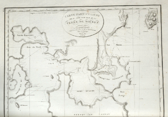
Figure 7 Detail of Louis Freycinet’s Carte particulière de la côte sud-est
de la Terre de Diémen (février 1802)
Published in the Atlas accompanying Louis Freycinet’s Navigation et géographie
volume of the Voyage de découvertes aux Terres Australes (1812 [1814])
Secondly, he includes on the map the track charts of the boats from the two ships in which the survey was conducted, thereby showing that this was the work of several people. And finally, where he is able to confer names, he honours officers and midshipmen from the expedition who were involved in the reconnaissance – Ransonnet and Brue, for example. In acknowledging the contribution of his fellow expeditioners, Freycinet thus demonstrates a spirit of inclusivity in his mapping project and strengthens his claim for recognition of the collective effort.
It should be noted, however, that Freycinet is somewhat selective in identifying the companions on whose behalf he makes this claim. For him, the science of cartography was a defining characteristic of the accomplished naval officer and represented a noble maritime form of knowledge. To be worthy of belonging to this club, an officer needed to have been formed in this tradition, and this, in his view, completely disqualified his commander, Nicolas Baudin, whose status as an outsider had been a bone of contention for Freycinet and several other officers on the expedition right from the start. The collective group with which Freycinet identified, and whose cause he was championing, thus excluded the very man who had ordered them to undertake their cartographic work and who had been responsible for the whole project. The collective group Freycinet was defending was in fact a very exclusive club.
But even within that club, there were limits to Freycinet’s solidarity. In taking on responsibility for the mapping project and for completing the narrative of the expedition, Freycinet was also investing heavily in his own personal quest for recognition. And that meant that he needed to take his distance from work that he knew might be flawed, or over which he had not had oversight. In his Navigation et géographie, he meticulously notes any limitations or conflicts there may have been in the measurements and observations on which he has had to base his maps. And where he presents maps that others have made, not only does he ensure that his name does not figure on the attribution (as in the map of Murat Bay, for example), but he also relinquishes all responsibility for them.
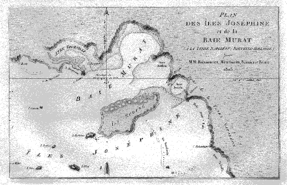
Figure 8Plan des Îles Joséphine et de la Baie Murat
(St Peter Islands, Nuyts Archipelago and Murat Bay, the main branch of Denial Bay),
Ransonnet, Montbazin, Bernier & Faure (1803)
Published in the Atlas of the Voyage de découvertes aux Terres Australes (1811)
As he says in his narrative: “Although the great majority of the maps in question were made by me, nevertheless there are some which belong exclusively to M. Boullanger, M. Faure and several other of my travelling companions, and for which they alone are responsible. I will state with the greatest care what has been the contribution of each person, being unable to answer for the work of others and not wishing that anyone other than I should sanction my own.” A collective undertaking it may have been, but Freycinet ultimately drafted most of the maps himself, and in this way was to differentiate his role from the work of his companions.
This provides an essential point of contrast with Baudin. In the unfinished fair copy of his log, or his personal journal as it is sometimes called, Baudin includes the many reports made by his scientists and officers on various aspects of their work. His is a “multi-voiced” document that clearly presents the expedition as a collective enterprise. It is ironic to note that Freycinet, through his publication of the maps and the accompanying narrative, has likewise produced something of a multi-voiced account of the voyage and has thus found a small degree of common ground with the man he so despised and whose name he sought to expunge from the story of the expedition. But in contrast to Freycinet, Baudin did not exclude from his narrative the people who irritated or otherwise displeased him. On the contrary, he trusted his specialist officers and scientists to do their job properly, and had no hesitation in reproducing their work, despite what he may have thought of them personally. Freycinet’s maps and narrative, on the other hand, are selective in the voices he allows to be heard, and it is clear that he assumes complete control over the collective undertaking.
And this is the final irony: perhaps inevitably, in assuming the moral authority for the expedition, Louis Freycinet has constructed a narrative that, despite the occasional nod to the collective group, is ultimately single voiced, in imperial mode. As such, it stands not only in contrast to Baudin’s more idiosyncratic style but also to the Republican ideal towards which the attributions of the maps in Freycinet’s atlas still superficially gesture. However, it should perhaps be acknowledged that authority has its uses – in navigation, in science, in art – as the maps themselves can testify. In their singular elegance, do they not in fact provide a remarkable example of order wrested from chaos? An act of personal redemption signed Louis Freycinet.