
olf Mayer
Introduction
The second half of the eighteens century and the early decades of the nineteenth saw an heightened interest by European governments, particularly those of France and Great Britain, in the wider Pacific region, including Australia. More than a dozen expeditions, commanded by outstanding navigators that included James Cook, Antoine de Bruni d’Entrecasteaux, Matthew Flinders and Nicolas Baudin, visited and explored this part of the world. The charts of the Australian coasts which these and other expeditions produced eventually resulted in the publication of the first complete map of Australia by Louis de Freycinet, in 1811. This map finally revealed the true configuration of the continent and its surrounding islands and fixed their positions firmly on the face of the globe.
The officers and geographers of Baudin’s expedition, on which Freycinet served as a lieutenant, made substantial contributions towards the charting of the then still unknown parts of Australia’s southern coast. However the expedition’s naturalists, in surveying the nature of the land and in studying and collecting specimens of its flora and fauna, added a new dimension to the bare outlines of these maps which revealed images of the country’s physical appearance and of its living environment.
An age of discovery and scientific innovation
Nicolas Baudin’s voyage to Australia took place during a time of intense interest and engagement in science in Europe, which lead to significant innovations and advances in knowledge. The fast-growing domain of science was then in the process of being split into separate disciplines, such as chemistry, geology, botany and zoology. Studies in greater depth of the Earth’s physical matter and of its natural environments now required specialists in particular fields of scientific investigation. Enquiries were increasingly carried out by experiment and by detailed observation in laboratories and in the field, and conclusions reached were based on verifiable evidence, rather than being influenced by dogma and preconceived ideas.
The gathering of such scientific evidence was vastly aided by the great voyages of exploration that were undertaken at this time. Navigators and their accompanying naturalists explored distant and little known parts of the globe, from where they often returned with large collections of animals and plants, both alive and preserved, as well as with a wide range of mineral and rock specimens. These greatly enriched museums and contributed to a more comprehensive knowledge and understanding of the nature of the world.
But this flourishing of scientific endeavour was not, as in former times, of interest only to the well-educated few. In these more enlightened days, new discoveries, new ideas and new perceptions of the nature of our world also fired the imagination of a wider public. Many lay persons now read books on science –often written by women – and attended public lectures on scientific topics. Scientists were sometimes treated like celebrities, poets were inspired by scientific revelations and, vice versa, men of science, in the spirit of the time, often expressed their sentiments in poetry. It became a status symbol for homes to include a natural history cabinet, displaying collections of curious objects which could be shown-off to visitors. Even ladies could be seen roaming the countryside and the sea shore carrying geological hammers, intent on making their own discoveries of natural curiosities.
Baudin’s expedition
In was during such a time of widespread public and professional interest and support for scientific pursuits that Napoleon Bonaparte, in the year 1800, authorised Captain Nicolas Baudin (fig. 1) to undertake a challenging voyage of discovery to New Holland, the country we now refer to as Australia.
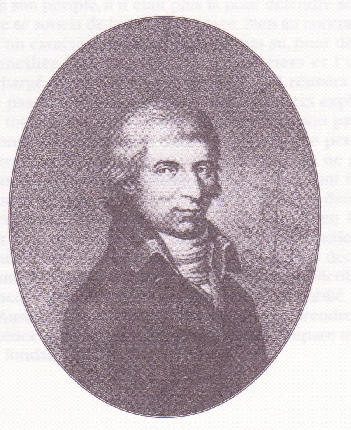
Figure 1 Captain Nicolas Baudin (1754-1803),
Commander of the French expedition which visited Australia between 1801 and 1803
Given the eagerness and enthusiasm for the acquisition of new knowledge at the time, it was not surprising that many scientists should want to be part of this expedition, which promised them a rich harvest of new discoveries, as well as a share in the glory and prestige such an enterprise was expected to bring.
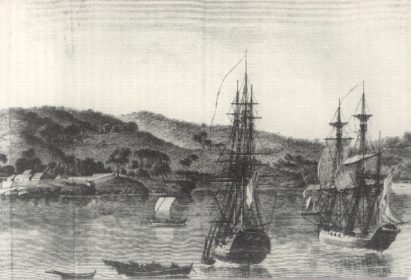
Figure 2 The expedition’s ships, the Géographe and the Naturaliste,
during a stopover in the harbour of Koupang, in Timor
As a result the expedition’s two ships, the Géographe and the Naturaliste (fig. 2), left Le Havre with the largest number of scientific personnel to have participated in any voyage of discovery, up to that time. However the hardships imposed by such a long voyage, together with personal issues, prompted a number among them to leave the two ships during a stop-over at Mauritius, so that only 14 of the original 24 investigators would step ashore on Australian soil.
These included Pierre-François Bernier, the astronomer, Louis Leschenault de la Tour, who served as botanist, the geographers Charles-Pierre Boulanger and Pierre Faure, Louis Depuch and Charles Bailly, the expedition’s geologists, the zoologists René Maugé, François Péron and Stanislas Levillain and the gardeners Anselm Riedlé, Antoine Sautier and Antoine Guichenot. In addition, the scientific party included the then indispensable artists Charles-Alexandre Lesueur and Nicolas-Martin Petit. Sadly, several among them succumbed to illnesses, common on such voyages, and two more delayed their return, so that only six of the original complement, three scientists (Boulanger, Bailly and Péron), one of the gardeners (Guichenot) and the two artists, returned to France with the expedition. François Péron (fig. 3), the most active and versatile among the naturalists, was given the task of writing the history of the voyage.
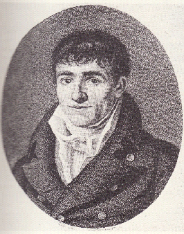
Figure 3 François Péron (1775-1810)
After his early death in 1810, Louis de Freycinet (fig. 4) completed this task. The account below relates some of the highlights of the expedition’s discoveries and achievements.
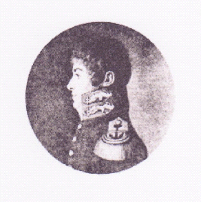
Figure 4 Louis de Freycinet (1779-1842)
The nature of the land
The charting of then still unknown parts of Australia’s southern coast by Baudin’s geographers and officers, an activity they shared at the time with Matthew Flinders and James Grant, proved beyond any doubt that the continent formed one single landmass. Their surveys put to rest for all time speculation that an arm of the sea, running from north to south, divided the continent into two parts, and conclusively determined its outline.
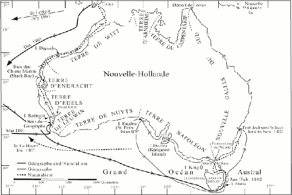
Figure 5 Map of Australia showing the routes followed by the Géographe and the Naturaliste
Sailing along the western and southern parts of Australia’s coasts (fig. 5), Baudin’s naturalists used every opportunity to examine and to describe the topography of the land and its rock formations. They were the first to conduct a partial geological survey of Australia’s coastal regions.The artist, Lesueur (fig. 6), added valuable visual impressions to their findings in his drawings of coastal profiles.
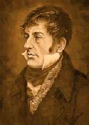
Figure 6 Charles-Alexandre Lesueur (1778-1846)
The voyagers felt at times confronted and depressed by the sterility and monotony of the low-lying land they encountered in the west and southwest of the continent (fig. 7), and were amazed by the vast extent of the sand dunes which lined its shores.
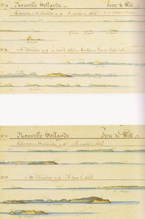
Figure 7 Profiles of parts of the western coast of Australia drawn by Lesueur.
Muséum d’histoire naturelle, Le Havre
The predominantly red colour of the sand prompted Boulanger, one of the geographers, to refer to this part of the continent as the Iron Coast (fig. 8).
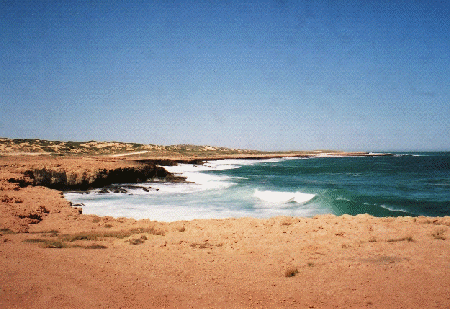
Figure 8 Red and grey-coloured sand dunes and iron-bearing rocks along the margins of Western Australia. Boulanger, the expedition’s geographer named these parts of the country the Iron Coast
The considerable geological expertise among the naturalists allowed them to identify limestone outcrops on Rottnest Island and, later, to recognise rocks at Shark Bay, hundreds of kilometres to the north, of identical composition (figs. 9 and 10).
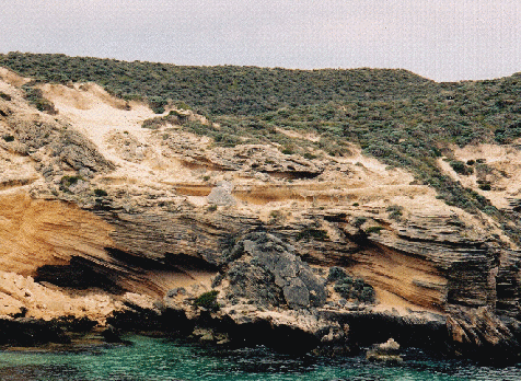
Figure 9 Outcrop of cross-bedded limestone on Rottnest Island
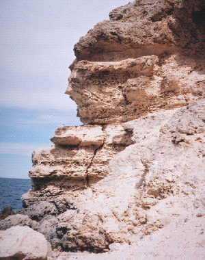
Figure 10 Outcrop of cross-bedded limestone at Shark Bay, which the expedition’s naturalists identified as being identical in composition with that seen earlier on Rottnest Island
Establishing the physical extent of a particular rock formation over such vast distances was of considerable interest and significance to geological science. They noted the lack of rivers entering the sea in these regions and were therefore eager to follow the course of the Swan River, the one major waterway they encountered, and which had been discovered by Dutch explorers more than a hundred years earlier (fig. 11).
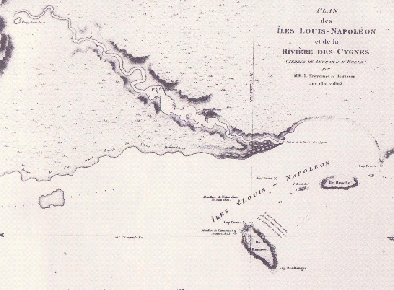
Figure 11 Map of the Swan River.
The bolder line marks the course of the river followed by Ensign Heirisson’s party.
National Library of Australia
During a troublesome journey in a small boat that lasted five days, they followed the course of this river as far as today’s Henley Brook, a distance of some 60 kilometres (fig. 12).
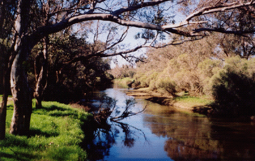
Figure 12 – The Swan River near today’s Henley Brook,
marking the furthest point reached by Heirisson’s party
Led by Ensign Antoine-Boniface Heirisson, they were the first Europeans to observe and describe the higher ground which forms part of the Darling Ranges (fig. 13).
Figure 13 View of the Darling Ranges from the banks of the Swan River, near Henley Brook
Charles Bailly, the mineralogist who accompanied the party, gave the first account of the geological features along the banks of the river.
In contrast to the arid western coast, the travellers admired the ‘lofty mountains and the broad plateaux’, of Tasmania (figs. 14 and 15).
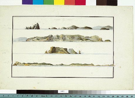
Figure 14 Coastal profiles of south eastern Tasmania.
Lesueur has accurately drawn the columns of dolerite rock
which outcrop extensively in this part of the island.
Muséum d’histoire naturelle, Le Havre
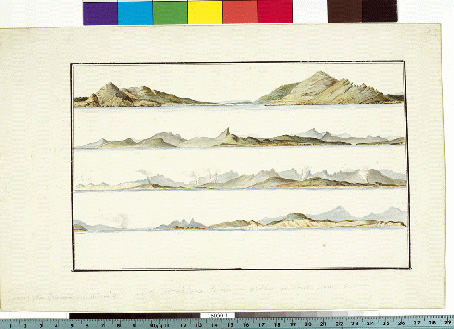
Figure 15 Coastal profiles of eastern Tasmania.
Note the smoke rising from many fires along the coast lit by Aborigines.
Muséum d’histoire naturelle, Le Havre
A party rowed up the Derwent River as far as today’s Bridgewater (fig. 16) in the year before Lieutenant John Bowen established his settlement at Risdon Cove. They also preceded Colonel Paterson up the Tamar River two years before he founded Yorktown.
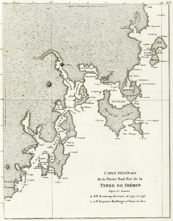
Figure 16 Map of south eastern Tasmania, showing the course of the Derwent River,
which was named Rivière du Nord or North River by the French.
National Library of Australia
In examining some of the island’s geological features Péron, who had found petrified shells in rocks some 300 meters above sea level, and pebbles of the volcanic rock basalt along its shores, concluded that the Earth “at this extreme point in the eastern world, had experienced its upheavals and catastrophes” and “that it was, as everywhere else, ravaged by volcanic fire and submerged between the oceans”.His recognition of the universality of geological processes added to and reinforced the views reached by scientists in other parts of the world.
During their stay at Sydney Cove the expedition’s geologists, Louis Depuch and Charles Bailly, reached the foothills of the Blue Mountains, where geological processes had rejuvenated the ancient land surface and elevated it to higher levels. To Bailly these highlands appeared “like a vast curtain bordering the north-west horizon” (fig. 17).
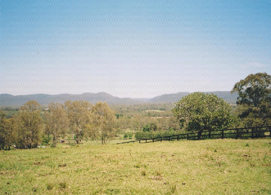
Figure 17 The Blue Mountains as seen by the geologists Bailly and Depuch
from the banks of the Hawkesbury River
When from the deck of his ship, Captain Baudin later sighted “a chain of extremely high mountains” (the Snowy Mountains) further to the south, he correctly predicted the existence of a more extensive range of hills which he believed to stretch from Wilson’s Promontory in Victoria to Port Stephen in New South Wales. Péron, relying on additional information he had been given, felt confident in suggesting that these uplands represented part of a continuous chain that extended along the entire length of the continent’s eastern margin and formed what we now refer to as the Great Dividing Range (fig. 18).
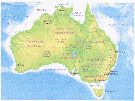
Figure 18 The Great Dividing Range along the eastern margin of the Australian continent
The descriptions and illustrations of Australia’s coastal regions by members of Baudin’s expedition gave Europeans the first detailed impressions of extensive parts of the country’s landscape and presented them with an accurate image of the southern land along long stretches of its coasts.
The living environment
Of even greater interest to Europeans however, was the arrival in France of a simply staggering number of animal and plant specimens, many of them not seen before, which hugely increased the holdings of the Museum of Natural History in Paris. The collections amassed by the naturalists, consisted of more than 3 800 preserved animal specimens, 1 500 types of dried plants and tens of thousands of seeds. It provided scientists with material for many years of study. The appeal of these collections was greatly enhanced by Lesueur’s beautiful drawings of Australian land and sea animals, which by their diversity and strangeness astonished scientists and members of the public alike.
Lesueur had made drawings of an extensive range of Australian animals that included sea shells (fig. 19),
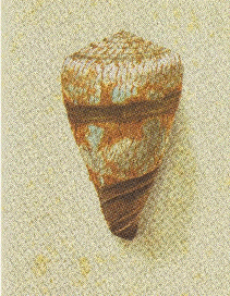
Figure 19 Gastropod shell, Conus miles, from the northern coast of Australia.
Muséum d’histoire naturelle, Le Havre (http://lehavre.fr/)
fish of unusual shapes and colours (fig. 20),
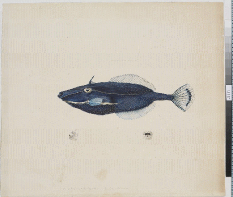
Figure 20 – A species of fish commonly referred to as leatherjacket,
Acanthaluteres spilomelanurus, from the waters of southern Australia.
Muséum d’histoire naturelle, Le Havre (http://lehavre.fr/).
varieties of frogs (fig. 21),
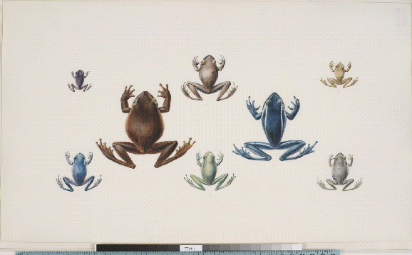
Figure 21 Frogs belonging to the genus Litoria, from Sydney Harbour.
Muséum d’histoire naturelle, Le Havre (http://lehavre.fr/).
multi-coloured birds (fig. 22),
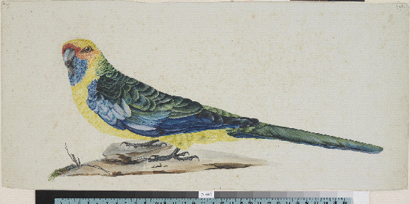
Figure 22 – A rosella, Platycercus caledonicus, from Tasmania.
Muséum d’histoire naturelle, Le Havre (http://lehavre.fr/).
and larger animals such as wallabies (fig. 23),
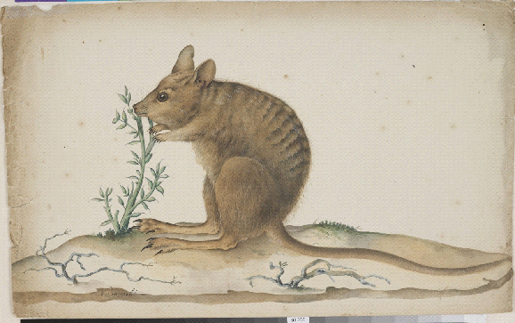
Figure 23Lagostrophus fasciatus, a striped wallaby from Shark Bay.
Muséum d’histoire naturelle, Le Havre (http://lehavre.fr/).
and kangaroos (24).
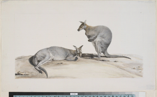
Figure 24 The grey kangaroo, Macropus rufogriseus.
Muséum d’histoire naturelle, Le Havre (http://lehavre.fr/).
Large collections of dried plant specimens also found their way to Paris (figs. 25 and 26).
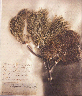
Figure 25 A dried specimen of Banksia spinulosa, collected by Leschenault in the Sydney area.
From the collection held in the Muséum nationale –d’histoire naturelle in Paris.
© MNHM – Patrick Lafaite
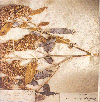
Figure 26Pomaderris lanigera, a shrub with yellow flowers, belonging to the family Rhamnaceae. From the collection held in the Muséum nationale d’histoire naturelle in Paris.
© MNHM – Patrick Lafaite
In addition to preserved specimens, the two ships returned to France carrying a number of live animals and plants. Kangaroos could soon be seen to graze in Madame Bonaparte’s park at La Malmaison (fig. 27), where they shared space with emus and black swans. In years to come, Australian plants would flourish there and in other parts of France, particularly in the south of the country.
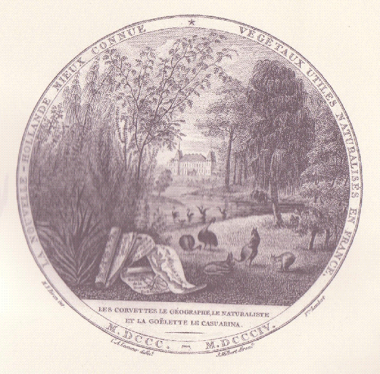
Figure 27 Australian animals and plants in the gardens of La Malmaison.
The inscription reads: New Holland better known – useful, naturalised plants in France
Live emus collected by Baudin on King Island and on Kangaroo Island, two of which survived the voyage to France, proved to be of particular interest to scientists and delighted the general public by their unfamiliar appearance. They represented species of the dwarf emus Dromaius ater andDromaius baudinianus, which would become extinct in Australia in around 1836. First displayed in Madame Bonaparte’s garden, they later became part of the menagerie of the Jardin des Plantes in Paris. There they continued to live for a further 18 years. Specimens of these birds, preserved today in the Museum of Natural History in Paris, provide us with the only complete evidence of their former existence (fig. 28).
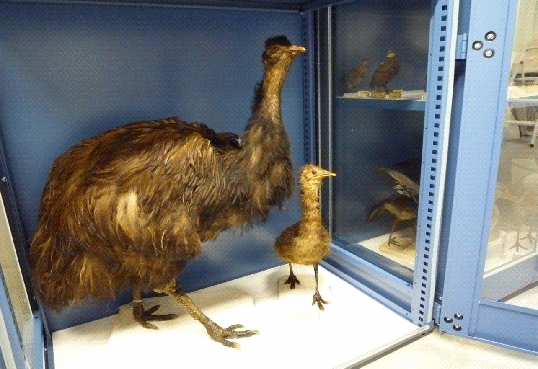
Figure 28 Preserved dwarf emus in the Museum of Natural History in Paris
The expedition’s naturalists, in addition to collecting and describing animals and plants also made detailed studies of the environment in which they lived. Péron, for instance, closely observed sea elephant or elephant seals (Phoca probiscidea) on King Island (fig. 29), which grew to a length of almost ten meters.
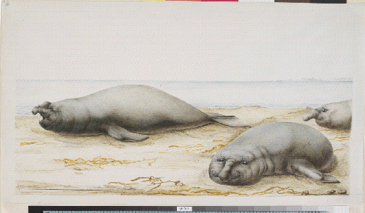
Figure 29 Sea elephants, Phoca probiscidea, at King Island, Tasmania.
Muséum d’histoire naturelle, Le Havre (http://lehavre.fr/).
He provided the first detailed description of their anatomy, life cycle, feeding habits and social interactions. He also described the methods of hunting these animals, and the resulting trade. Sadly, their usefulness to man has long since resulted in the creature’s demise from King Island.
On Rottnest Island Péron recognised that the little furry creatures, taken for large rats by early Dutch explorers – rat = rot in Dutch, hence the name of the island – did in fact represent “a new, very remarkable species,”which we now refer to by the common name of quokka (Setonix brachyurus) (fig. 30).
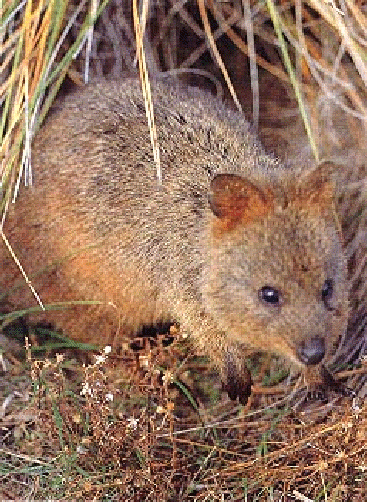
Figure 30 The quokka, Setonix brachyurus, on Rottnest Island
But this naturalist made an even more remarkable discovery when exploring along the shorelines of Bruny Island in Tasmania. On one of its beaches he picked up shells which proved to be specimens of the genus Trigonia.
What was so remarkable about this find was that this mollusc had been believed to be long extinct. It had only been known from its fossilised remains in Europe, where it was found in rocks close to 100 million years old. Yet, here in Tasmania this shellfish was clearly still alive and well (figs. 31 and 32).
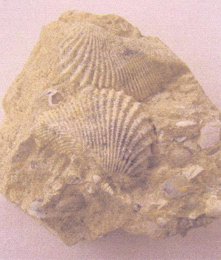
Figure 31 Fossilised shells of the genus Trigonia
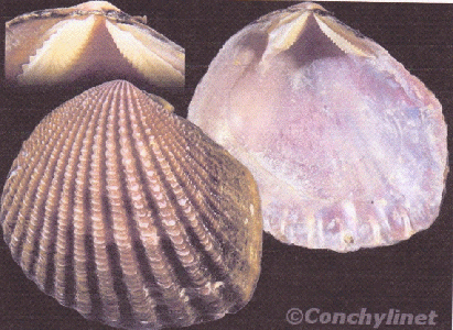
Figure 32 Shells of the genus Trigonia found today on beaches of southern Australia
The news of the survival of the genus in waters of the southern continent was greeted with both amazement and delight in Europe. The famous zoologist Jean-Baptiste de Lamarck wasted no time in providing the scientific community with a detailed description of the find in a journal article, published not long after the expedition’s return (fig. 33).
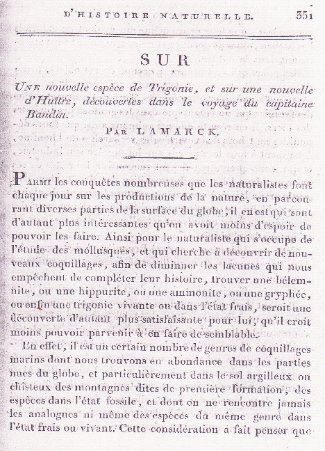
Figure 33 Lamarck’s article on a new species of Trigonia
The existence of this so-called ‘living fossil’, and the finding by other members of the expedition of more shellfish thought to have been extinct, led a number of scientists to question the long-held view of the former existence of a universal ocean in which particular organisms had all died out, at the same time, across the entire globe. Instead, ideas emerged which suggested that changes in the extent and shape of the world’s oceans had created environments which allowed some organisms to survive in particular parts of the world, but not in others. We know today that the genus Trigonia has survived only along parts of Australia’s southern coasts. These discoveries by the Baudin’s naturalists would, in time, contribute to a radical change in thinking about the geological history of the Earth.
Baudin and, in particular Péron, had been given instructions to also make a study of the native inhabitants of the southern continent. The French naturalist Bernard de Lacépède went so far as to suggest that this may be the first expedition to have man as the object of its study. The accounts by the expedition’s naturalists and officers, including Baudin himself, gave an early insight into Aboriginal society and the lives of the country’s original inhabitants. The physical features of Australia’s indigenous people, aspects of their culture and some of their daily activities, were beautifully illustrated in the drawings of the expedition’s second artist, Nicolas Petit (figs. 34, 35 and 36).
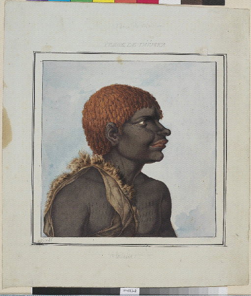
Figure 34 Portrait of a Tasmanian Aborigine, Ouriaga, from Bruny Island. Drawn by Petit.
Muséum d’histoire naturelle, Le Havre (http://lehavre.fr/).
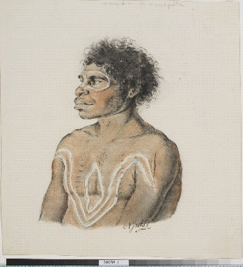
Figure 35 Portrait of a Tasmanian Aborigine, Mousquéda or Mousquita. Drawn by Petit.
Muséum d’histoire naturelle, Le Havre (http://lehavre.fr/).
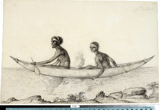
Figure 36 An Aboriginal man and a woman in a boat on Sydney Harbour. Drawn by Petit.
Muséum d’histoire naturelle, Le Havre (http://lehavre.fr/).
Achievements
Péron expressed the joint feelings of the investigators at the end of the voyage in Australian waters, when he wrote: “A sweet satisfaction then filled every heart. Each of us paused with a sort of pride over the great work that had just been completed. Rich with all the treasures that the nation had entrusted us with collecting on these distant shores, we felt their value increased for us by the privations and perils which, for the past two years in succession, we had to face in order to obtain them. And we said to ourselves: ‘More fortunate than our predecessors … we have seen all the details of this immense land … we have penetrated into her vast gulfs, gone ashore on the islands and gathered important material everywhere for writing her story. Several thousand useful plants and animals of value to science were collected on these shores; we, ourselves, scattered there a multitude of seeds … May the dew from heaven favour them!’ …”
The painstaking and often dangerous work of Baudin’s naturalists, which cost some of them their lives, did indeed give the world the beginnings of a story of this strange and little known land, with its own special beauty and richness of life. While the expedition could only visit Australia’s coastal regions, it is fair to say that they took home with them a far greater knowledge and understanding of the southern continent than that possessed, at that time, by the British settlers. Baudin’s voyage of discovery deserves to rank alongside that of other, perhaps more famous expeditions, for its outstanding contribution to the charting of the coasts and to advances in the knowledge of the natural history of the southern continent.